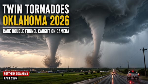
In April 2026, a dramatic weather event in northern Oklahoma captured global attention: two tornadoes forming side by side, moving in tandem, and appearing to interact in the same storm system. Often described as “twin tornadoes,” the footage quickly spread across social media and news outlets, drawing millions of views and raising questions about how such rare phenomena occur.
Oklahoma sits in the heart of Tornado Alley, a region of the United States known for frequent and intense tornado activity. Even so, the appearance of two simultaneous funnels within close proximity is unusual enough to spark both scientific interest and public concern. This event is more than just a viral video—it reflects broader patterns in extreme weather, climate variability, and the increasing visibility of natural disasters in the digital age.
How Twin Tornadoes Form and Why They Are Rare
Tornadoes develop from powerful thunderstorms, particularly supercells, which contain rotating updrafts known as mesocyclones. Under the right atmospheric conditions—strong wind shear, warm moist air near the ground, and cooler air aloft—these rotating systems can tighten and extend downward, forming a tornado.
In some cases, a single supercell can produce multiple vortices. These can appear as satellite tornadoes orbiting a larger funnel or as separate funnels developing simultaneously within the same storm structure. This is often what people refer to as “twin tornadoes.” While not impossible, it requires a very specific combination of atmospheric instability and storm dynamics.
The Oklahoma event in 2026 appeared to involve two funnels forming close together and moving within the same storm system. At certain moments, they seemed to converge or overlap visually, creating the striking impression of merging tornadoes. Meteorologists note that while tornadoes can interact, the visual effect is often influenced by perspective, storm rotation, and debris patterns.
Events like this are rare because they depend on highly unstable atmospheric conditions. Tornado formation itself is complex; the simultaneous formation of two visible funnels within close range is even more unusual. That rarity is one reason why videos of twin tornadoes often go viral—they show something that most people will never witness in person.
Impact on Communities and Growing Weather Risks
While the visual spectacle of twin tornadoes captures attention, the human impact is far more serious. Northern Oklahoma experienced significant storm damage during this outbreak. High winds, flying debris, and structural destruction affected homes, infrastructure, and local businesses. Emergency services responded quickly, conducting search and rescue operations and providing aid to affected residents.
Tornadoes remain one of the most dangerous natural hazards in the United States. They can form quickly, change direction unpredictably, and cause severe damage within minutes. Even relatively small tornadoes can result in injuries, displacement, and long-term economic consequences for communities.
Events like the 2026 Oklahoma outbreak also highlight the importance of early warning systems. Advances in radar technology and forecasting have improved the ability of meteorologists to issue timely alerts. However, public awareness and preparedness remain critical. Knowing where to seek shelter and how to respond during severe weather can make a life-saving difference.
In recent years, there has been growing discussion about whether extreme weather events are becoming more frequent or more intense. While tornado data can be complex to interpret, many scientists agree that climate variability is influencing atmospheric patterns. Warmer temperatures can increase moisture in the air, potentially fueling stronger storms. Although no single event can be directly attributed to climate change, the broader trend toward more unpredictable weather is a concern for both researchers and policymakers.
Why Twin Tornado Videos Go Viral in the Digital Age
The Oklahoma twin tornado footage is also a powerful example of how modern media shapes our perception of natural events. With smartphones and high-speed internet, individuals can capture and share dramatic moments in real time. A local weather event can become a global headline within hours.
Videos of rare phenomena—especially those that are visually striking—tend to spread rapidly across platforms. The image of two tornadoes side by side is both fascinating and unsettling, making it highly shareable. Keywords such as “rare,” “shocking,” and “caught on camera” often drive engagement, drawing attention from audiences who might not normally follow weather news.
At the same time, viral content can blur the line between information and spectacle. While dramatic footage raises awareness, it can also lead to misunderstandings about how these events occur. This is why expert analysis from meteorologists and reliable reporting are essential. They provide context, explain the science, and help the public understand both the risks and the realities of severe weather.
The increasing visibility of extreme weather events has both positive and negative effects. On one hand, it promotes awareness and preparedness. On the other, it can contribute to anxiety and misinformation if not properly contextualized. Responsible sharing and accurate reporting play a key role in ensuring that viral content serves an informative purpose.
The twin tornadoes in Oklahoma in 2026 are a reminder of both the power of nature and the role of technology in shaping how we experience it. What might once have been a local event is now part of a global conversation about weather, risk, and resilience. As communities continue to face the challenges of extreme weather, understanding these events—scientifically and socially—becomes more important than ever.